tl;dr I hacked up Renegade Crowns from WFRP with my own setting nonsense to create a similar kind of "petty kingdom chaos" generator that leans more to OSR style of scenario design and sandbox play, with (I hope) more concise tables. This is Part 1, generating the landscape.
Whole series here
Okay honestly the tl;dr pretty much captures it. I like making settings and maps and regions as an activity unto itself, and I've been noodling on various methods and systems for generating them for a while. Renegade Crowns provides a good structure for me to bolt my own nonsense and preferences onto. I also wanted to rebuild the tables to be more concise and compact. There's more dice than d100s, y'know. I also replaced Renegade Crown's weirdly patchwork set of biomes with a more consistent array that's based on northern Canada where I grew up because I do what I want.
If you're not familiar with Renegade Crowns, the idea is: there's a big patch of land between larger polities that no-one owns, no-one controls, and no-one really wants too much. So every man-who-would-be-king, exiled noble, jumped up bandit, ambitious adventurer, and pernicious priest comes down to carve out a little princedom of their own. It's a land of chaos, conflict, and opportunity, and there's a whole bunch of tables and advice for creating your own patch of perilous petty princelings.
My own tastes in setting are baked into these tables, but it wouldn't be hard to replace them with your own. I draw (incredibly inaccurately and with gleeful anachronism) from post-Roman Britain with a dash of the Late Bronze Age Collapse in the eastern Mediterranean. Point is, empires have fallen and there's lots of little people scrambling for land and power and safety. And then on top of that is the fantasy weirdness like fairies and demons and UFOs and occasional nuclear waste dumps and buried shopping malls. Normal stuff.
The idea at the end of all this to have a system that can generate big chunks of this chaotic land on the fly, complete with basic history, adventuring sites, settlements, and the jerks trying to make themselves king jerk, and then take all that big picture and run it as a hex crawl and domain game. There should be loads for players to do, even if they don't decide to make themselves Princes, too. The first part, down below, is about generating the landscape and some special features that make up the region.
Here's some assumptions I make. You can skip this section entirely if you don't care.
The World is in Flux. It is a time between empires. This part of the world is sliding into a dark age. There are places, beyond the reach of the common folk, that are ticking along just fine or having their own golden age (see: most of the world during the Dark Ages in western Europe). Nobody knows if a new power will be forged out of the chaos, or who it will be. Power is rarely transferred smoothly between generations. Whole populations are on the move, driven from their own lands and seeking to take someone else's.
Religion is a Big Deal. Religion is how people make sense of the world, seek surety in a chaotic time, and defines their identities versus the other. And religions are in conflict. New, organized religion seeks to wipe away the old faiths. Migrating peoples bring their gods with them, and are both horrified and fascinated by the practices they encounter. And, because this is fantasy, there's demons and gribbly Elder Things and shit looking for their chance to reach into our reality.
Change is Possible, but Hard. Unlike that game that bills itself as perilous and grim I'm not gonna say all your works will crumble and lasting creation is impossible, but it is hard. A bunch of jerks with swords and spells and the will to use them might weld together a patch of land and call it a kingdom, but creating a true nation is the work of an entire people acting together. And not everyone thinks that putting another jerk with a sword on a throne is the best long-term plan...
Magic is Heckin' Scary. Magic and mages are dangerous, to themselves as much as anyone else, and most people never see actual magic. There's no oddly modern academia out there organizing mages with a sorting hat saying whether they're good at illusions or blowing shit up, there's just some bent mf'ers who warp reality and are more likely to kill each other for formulas than invent tenure.
Layers of Civilization. The history breaks down like this:
- Pre-Apocalyptic. The (mostly) buried remains of a world that looks a lot like ours, ended in fire and calamity. Think Adventure Time but more buried & hidden.
- Ancient. Neolithic times. Humans in stone huts and living side-by-side with giants and fairies.
- Druidic. The original inhabitants of this land. A druidic, clannish Bronze Age people with heroes and gods and sweet tattoos. They built stone circles and hill forts and raided cattle.
- Imperial. Some bunch of jerks followed a bigger jerk and conquered the known world into one big empire. The head jerk died, but the empire stuck around for several centuries and did a decent job of making everyone talk and worship like them. Until they couldn't any more, and collapsed into chaos.
- Recent Human means the last hundred years or so. Imperials who stuck around after the empire collapsed and have been creating a new identity. Outsiders who came to settle and took up the empire's god for their own. The remaining druidic people, though they've mostly taken up the imperial god, too. Newer invaders, the ones who come from a land of ice and snow and hotsprings and are quite happy with their own gods, thanks.
PART ONE: LANDSCAPING
Okay so first we'll need some hexes to fill. A single HEX is 4 miles across - thus in a day you can cross two hexes in open terrain, three on a road, or one in difficult terrain (assuming your elfgame of choice doesn't say otherwise). A hex of hexes, five across and nineteen total is a MEGAHEX. Nineteen of those in a matching five-across arrangement is a GIGAHEX. That's a total of 361 hexes, for a total area of just over 5000 square miles (or just shy of thirteen thousand square kilometers, for those of us free of imperial measurements in normal daily life and yet shackled to them by the conventions of elfgames).

The first step is to fill in the biomes and any special natural features. Roll on the BIOME table to fill in the hexes, then roll on the sub-table for how many hexes to fill.. If you want to randomize where a biome starts or a special feature is located, roll a d20 to pick a MEGAHEX. If you want the specific hex, repeat the d20 roll within the MEGAHEX.
Roll a d12 & d4 on BIOMES. The d12 is which biome, the d4 is for the sub-table of how many hexes that biome will fill.
BIOMES (d12 & d4)
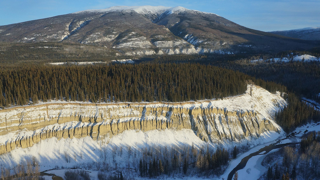
1 - HILLS (1-2 3d20, 3 d100, 4 d20x10) (1-3 Rocky, 4-6 Forested)
2 - MOUNTAINS (1-2 3d20, 3 d100, 4 d20x10) (1-3 Low, 4-6 High)
3 - FOREST (1-2 3d20, 3 d100, 4 d20x10)
4 - PLAIN (1-2 3d20, 3 d100, 4 d20x10)
5 - WETLAND (1-2 d20, 3 2d12, 4 3d12)
6 - RIVER
7 - LAKE (1-2 d4, 3 d6, 4 d10)
8 - CLIFF (1 d4, 2 d6, 3 d8, 4 d10)
9 - FERTILE VALLEY (1-2 d12, 3 d20, 4 3d10)
10 - HAZARD ZONE (1-2 d12, 3 d20, 4 3d10)
11+ - SPECIAL
SPECIALS (d12)
1 - CAVES
2 - BUTTE
3 - VOLCANO
4 - WATERFALL
5 - RAPIDS
6 - HOTSPRINGS
7 - CRATER
8 - EPIC PEAK
9 - ROAD (d20 long) (1-2 Imperial, 3-4 Druidic, 5 Ancient, 6 Pre-Apoc)
10 - BRIDGE (1-2 Imperial, 3 Druidic, 4-5 Ancient, 6 Pre-Apoc)
11 - CANYON (d12 long, with side branches d4 long for every 5 full hexes)
12 - NECROPOLIS (d4 layers: Recent, Imperial, Druidic, Ancient)
9 - ROAD (d20 long) (1-2 Imperial, 3-4 Druidic, 5 Ancient, 6 Pre-Apoc)
10 - BRIDGE (1-2 Imperial, 3 Druidic, 4-5 Ancient, 6 Pre-Apoc)
11 - CANYON (d12 long, with side branches d4 long for every 5 full hexes)
12 - NECROPOLIS (d4 layers: Recent, Imperial, Druidic, Ancient)
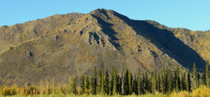
HILLS
.jpg/640px-Faro%2C_Yukon_(12602715134).jpg)
.jpg/640px-Hills_between_Keno_City_and_Mayo%2C_Yukon_(3894726853).jpg)
- Steep-sided hills that tend to form long, parallel ridge-lines.
- Forested hills are low and gently sloped enough to have tree coverage on the top, typically boreal spruce forest. Hills that have been tended or terraced may be able to support orchards (apples, pears, and berries in particular) or vegetable and gourd farming.
- Rocky hills are higher and steeper and have a defined tree-line part way up or at the base and often have boulder-strewn approaches, rockslides, and steep escarpments. The soil on top is rarely thick enough to support much more than hardy grasses, but they can provide grazing land for goats, sheep, and ponies.
MOUNTAINS
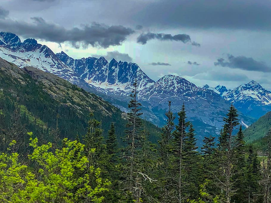
- Steep, jagged mountains. Glacier-scraped and volcanic rock.
- Low mountains have a squat appearance, with a broad profile and a low, wide peak. The tree line is defined, though it may reach most of the way up. These mountains have thin soil, supporting only stunted spruce trees. The thin grass on the summits is unlike to support anything but the hardiest of goats.
- High mountains are steep and have sharp ridge-lines. The tree line reaches only to the foot of these mountains, and the peaks are snow-capped year round.
FOREST


- There are two primary types of forest in the region. Neither support the giants of more southern lands, and a tree that survives fifty winters might not top twenty feet.
- In valleys, lowlands, and other areas with water and fertile soil grow primarily aspen and poplar forests. These trees grow quickly (relatively, for the region) and are commonly used for building material. These types of forest, if cleared and irrigated, can support farming - mostly cold-tolerant crops like bere and rye, with oats and some wheat near the coast, though the short growing season and thin soil limit harvest size.
- In higher elevations and where the coastal rains are blocked by mountains the forests are dominated by spruce trees. These forests are unsuited for grain farming, as the soil is thin, rain is scarce, and permafrost is not far below the surface. Vegetables, roots, and gourds can be grown, as can berries and flowers.
PLAIN
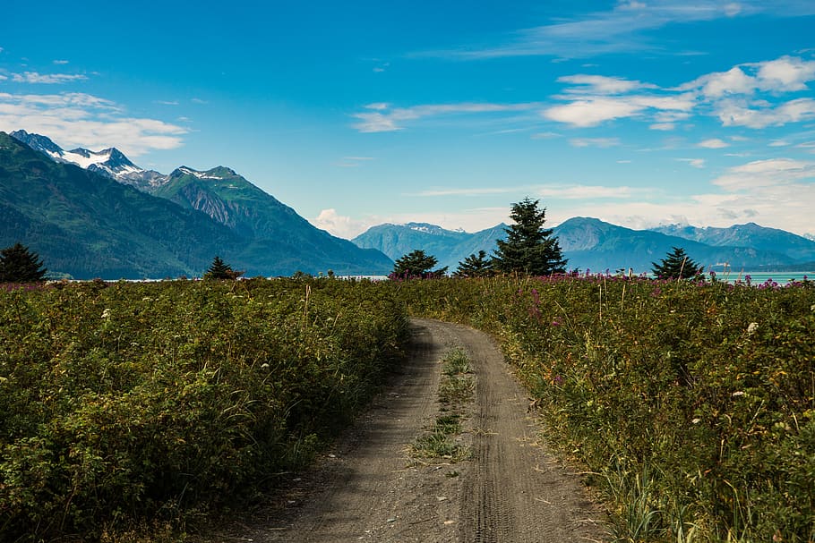

- Plains in low-lying areas exist only as a result of deforestation by human hands. The Druidic and Imperial people both engaged in land clearing for agriculture, though many of those areas are slowly returning to forest without active maintenance and farming. If they can be worked (and defended) these plains can become productive farmland.
- Plains at higher elevations are tablelands, high plateaux swept by bitter winds and receiving little water beside snow. They may be dotted with small, twisted spruce or small groves of aspen around springs and streams, but are mostly tough grass, lichens, and rocks. In spring and summer these areas explode with colour as the wildflowers bloom.
WETLAND
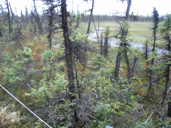

- Near the coast and along rivers wetlands are marshes - dominated by grasses, reeds, bushes, shallow ponds, and few trees. Crossing marshland is difficult, as the shallow pools and soft ground cannot be crossed with boats, while also being dangerous to walk through.
- Inland and at higher elevations, wetlands are muskeg bogs. These peat bogs form when groundwater can't drain due to permafrost and the weather is too cold for major evaporation. The wet ground and plant life decay and form thick peat deposits. Grasses and stunted spruce trees dot the surface of a muskeg bog, along with moss and shallow water. Muskegs can be extremely difficult to cross and deceptively dangerous. What looks like a moist, grassy field may actually be peat and moss mats floating atop standing water and thick mud, ready to suck the unwary down into the mire.
RIVER


- When placing a river, remember that rivers flow from high ground to low, join but do not split (except in deltas) and all flow in roughly the same direction - to the sea.
- If you need a random hex within a MEGAHEX for a river to start or exit, roll d20.
- At high elevations, rivers are fast, narrow, and straight. Rapids are common.
- At low elevations, and around wetlands, rivers may be wider, slower, and wind more. Oxbow lakes sometimes form in broad valleys where the river has meandered.
LAKE
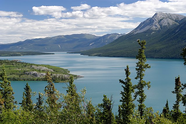

- Freshwater lakes, cold and still. Refreshed by snowmelt and freeze solid in the winter. Home to trout, pike. May fill a narrow valley between mountains, be created by a beaver dam, or be the confluence of several rivers. With limited evaporation, and bedrock and permafrost keeping water on the surface, lakes can grown immense - especially at the foot of mountains that shed snowmelt every spring.
- Moose frequent the shallows and marshy ground around lakes, and the wolves follow them.
- Control of a lake means control of traffic along it. Princes have fought sea battles with canoes and skiffs.
CLIFF
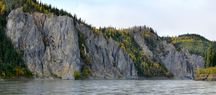
- Cliffs, typically formed by erosion and subsidence, form long boundaries between biomes. They might bound a flat river valley between mountains, form the edge of a high plateau, or separate coastal plains from inland hills.
- Cliffs bordering mountainous areas are typically sheer rock walls. The average height of such cliffs is 100+(d6x50) feet.
- Cliffs among hills and valleys are usually a long escarpment of exposed clay and softer soil and rock and as such may be scalable (with difficulty) without special equipment or training if one can find a lower section or a defile. The average height of such cliffs is 50+(d3x50) feet.
- A long cliff or escarpment is a significant barrier to movement, and ravines eroded by rivers, ancient roadways cut into the cliffs, or other places where the heights are easily traversable become significant military and commercial locations.
FERTILE VALLEY
- These vales are rare in the region, but they do exist. Often warmed by geothermal activity and with soil enriched by silt, volcanic ash, or perhaps a stranger force altogether, these small oases are capable of supporting life and agriculture like no other area in the land. As such they are some of the most densely populated, and most hotly contested.
HAZARD ZONE
- These are areas that are hostile to life, dangerous to enter, and often beyond contemporary understanding. Nuclear waste pollution, magic gone amok, alien terraforming, eldritch invasion, dimensional collision, mega-haunting, generational super-curse. Needless to say, no two are alike, and there is always sweet loot to those who can brave (and survive) them.
SPECIAL
These are single-hex special features that are significant enough to be widely known and even serve as landmarks. Smaller and less significant versions of all of these may exist in the region, but aren't important enough to affect the big picture.
- Caves. There is a large cave complex in this area, with multiple entrances and likely uncharted depths. Such large complexes are inevitably used as lairs for bandits, monsters, fugitives, renegades, devil worshipers, necromancers, and worse. They also typically connect to the Underworld. Usually found in rocky or raised terrain such as hills, mountains, and cliffs.
- Butte. Also known as a tor. A large, usually flat-topped outcropping of rock that projects out from a ridge or stands alone in lower terrain. Highly defensible and almost invariably occupied by a fortification or settlement. Or ruin.
- Volcano. An active cone. May not be erupting or even smoking, but absolutely has lava pools in the caldera and fresh magma in its veins.
- Waterfall. A significant waterfall. 100+d100 feet high. Place it on a cliff or mountain border, either on an existing river or add one.
- Rapids. A particularly savage and long stretch of treacherous waters in a river. The rapids are dangerous enough to prevent normal river travel, requiring portages or overland travel. If the river is a significant enough travel or trade route there may be one or more settlements built next to the rapids.
- Hotsprings. A large region of geothermal activity. Hotsprings, heated pools. geysers. Such locations often have healing properties and religious significance attached to them, but can also be a hazard crossing. Lava tubes and underground springs may connect this location to the Underworld.
- Crater. A large crater, broad enough to build a town in or be filled by a (poison) lake. Extinct caldera, meteor impact, bomb blast, alien crash site.
- Epic Peak. A singularly tall mountain peak. 10,000 + 100xd100 feet high. Upper slopes are likely impassable or unexplored. Almost always has mythic and religious significance.
- Road. No current Prince has the time, resources, or reach to build or even maintain proper roads. However, some roads from previous ages have withstood the test of time and remain usable. Commerce, people, and warbands all make use of them and they can be strategic hotspots. Imperial roads are graded and paved with slabs of stone. Druidic roads are of packed earth and stone, where the lingering magics have kept them free of root and weather. Ancient roads are lingering traces of neolithic times, raised causeways of cyclopean stone bricks. Pre-apocalyptic roads are asphalt and pavement with occasional remains of overpasses and off-ramps.
- Bridge. These bridge rivers, gap ravines, cross wetland. They remain vitally important to travel and commerce, as no Prince is capable of constructing new ones. Imperial bridges are arched brick and concrete marvels. Druidic bridges are petrified and shaped wood, living trees molded into spans and sturdy enough to defy time. Ancient bridges are simple, great cyclopean slabs sunk in the riverbed and spanned by further slabs. Locals now replace missing slabs with wooden planks in pale imitation. Pre-apocalyptic bridges are suspension bridges of rusted iron girders and crumbling asphalt.
- Canyon. Deep, steep-sided. Might be a river valley, a tectonic rift, caused by a vast collapse of part of the Underworld, the scar of an orbital laser, or the product of some magical calamity.
- Necropolis. A valley of the dead. A field of barrows. A tomb complex. Dozens or even hundreds of tombs, sepulchers, burial grounds, barrows, kurgans, and other large burial structures fill this area. It has been in use for a long, long time, may still be in use, and likely by more than one group. Looters are common, as are deadly traps and curses and guardians.
EXAMPLE

- Cliffs, 4 long
- Canyon, 6 long with a single 1-long branch
- Forest, 17 hexes
- River. The canyon seemed a logical choice.
- Cliffs, 8 long. The existing canyon and cliffs suggest a raised area, so these cliffs complete that.
- Mountains, 17. I put these in the centre, along the canyon. The river flows out of mountains, swollen with snow-melt.
- Special - Necropolis. Had two Ancient layers and one Imperial. Placed it on the western edge of the mountains. A valley of the dead.
- Forest, 81 hexes. Filled in the western edge of the area. Upcountry forests.
- Hills, 69 hexes. Connected the mountains down to the bottom of the region.
- Hills, 45 hexes. Put them along the top cliffs to complete the elevated area.
- Mountains. Didn't roll for hexes, just filled in the gap between the new mountains and the large western forest.
- Fertile Valley, 14 hexes. Put this in the lowland to the north-east, fed by the river coming down out of the mountains.
- Special - Caves. Put it at the base of the cliffs. Maybe it connects through the Underworld to the necropolis.
- Special - Butte. Put this on the western forest. Probably going to be the capital of whichever prince claims that area.
- Forest, 46 hexes. I reduced it to 29 and filled the top hexes but left a gap between this forest and the fertile valley.
- Special - Canyon. 12 long, with two branches 1 and 3 long. I put this through the western forest and hills to the northern cliffs, then put another river in it.
- Lake, 3 hexes. Put this at the base of the southern hills, then connected it by river to the canyon.
- Lake, 10 hexes. A big lake. Placed it on the east, next to the fertile valley.
- River. Added a river coming down out of the hills to feed the big lake, then connecting to the first river.
- Cliff, 5 hexes long. Put them between the big lake and the hills. That lake is probably going to be an important waterway for traffic getting around the cliffs.
- Wetland, 12 hexes. Put them south of the big lake and added another river coming from the south-east to feed the lake.
- Fertile Valley, 4 hexes. Upped to six and put them around the south-west lake in the hills. Secluded and remote, but valuable territory for princelings to fight over.
- Mountains, 27 hexes. Dropped it down to five and filled in the area east of the big lake.
- Special - Waterfall. The lake coming down out of the hills to feed the big lake seemed logical. There's obviously caves behind it.
- Special - Caves. Convenient. Put these next to the small lake in teh southern hills. Definitely connect to the caves behind the waterfall.
- Forest. Didn't roll for size, just filled in the last ten hexes south of the wetlands.
And that's the terrain and special features for this region. I could add another few special features, but I think the terrain is dense enough as it is Next step is placing Major ruins.
No comments:
Post a Comment